• NEW STUDY RELEASED ON ‘THUNDER THIGHS’ DINO IN UT

    Updated: 2011-02-28 14:28:13
    deseretnews.com Fossil remains of an athletic sauropod with a potentially mighty kick found in eastern Utah offer a rare bounty of clues into how four-legged herbivores thrived, according to a new study of the discovery. The results, published this week in the British journal Acta Palaeontologica Polonica, show that an unusually large hip bone compared to other [...]

  • Geology Links for February 28th, 2011

    Updated: 2011-02-28 09:00:03
    Links from del.icio.us, tagged with geology for February 28th, 2011: About SERC ??????????????????????? – ?????? – ?????????? – ??? penokean orogeny – Google Search Tectonic model for the Proterozoic growth of North America — Geosphere User:Bettymnz4/Penokean Orogeny – Wikipedia, the free encyclopedia MetSoc 2010 Main Page Home The Explorer’s Guide to Impact Craters The EMVC [...]

  • Daily Geology Photos – February 27

    Updated: 2011-02-27 17:20:14
    A summary of photos posted on flickr today, tagged with “geology.” Displayed below are 69 geology-related photos were added to flickr today. Similar Posts on Geology News: Daily Geology Photos – September 23 Daily Geology Photos – May 10 Daily Geology Photos – May 19 Daily Geology Photos – May 21 Daily Geology Photos – [...]

  • Geology Links for February 26th, 2011

    Updated: 2011-02-26 22:00:09
    Links from del.icio.us, tagged with geology for February 26th, 2011: Volcanoes – What is a volcano? – Te Ara Encyclopedia of New Zealand Tectonics of the M7 earthquake near Christchurch, New Zealand | Highly Allochthonous Geological Society of America – Educational K-12 Teacher Resources This Dynamic Planet USC Seismology – Home IRIS – Incorporated Research [...]

  • Daily Geology Photos – February 26

    Updated: 2011-02-26 17:20:12
    A summary of photos posted on flickr today, tagged with “geology.” Displayed below are 87 geology-related photos were added to flickr today. Similar Posts on Geology News: Daily Geology Photos – September 23 Daily Geology Photos – May 10 Daily Geology Photos – May 19 Daily Geology Photos – May 21 Daily Geology Photos – [...]

  • Daily Geology Photos – February 25

    Updated: 2011-02-25 17:20:05
    A summary of photos posted on flickr today, tagged with “geology.” Displayed below are 32 geology-related photos were added to flickr today. Similar Posts on Geology News: Daily Geology Photos – September 23 Daily Geology Photos – May 10 Daily Geology Photos – May 19 Daily Geology Photos – May 21 Daily Geology Photos – [...]

  • Geology Links for February 25th, 2011

    Updated: 2011-02-25 17:00:06
    Links from del.icio.us, tagged with geology for February 25th, 2011: NOAA Science On a Sphere 26051201.jpg (JPEG Image, 2269×1392 pixels) Diamond Mining & Geology OneGeology – Portal The FUNDAMENTALS OF PHYSICAL GEOGRAPHY USGS Education Geological Society of America – Educational Programs … Geology.com – Earth Science News, Maps, Dictionary, Articles, Jobs BBC News – CCTV [...]

  • Department of the Interior and University of Alaska Dedicate Climate Science Center

    Updated: 2011-02-25 05:42:49
    ANCHORAGE, AK —The Department of the Interior held a ribbon-cutting ceremony today for its new Alaska Climate Science Center (CSC), which is being hosted in Anchorage by the University of Alaska Fairbanks. The ceremony for the Alaska CSC marked the first official opening of one of eight regional climate science centers the department is establishing throughout the nation.

  • Drier Conditions Projected to Accelerate Dust Storms in the Southwest

    Updated: 2011-02-25 04:36:49
    MOAB, Utah — Drier conditions projected to result from climate change in the Southwest will likely reduce perennial vegetation cover and result in increased dust storm activity in the future, according to a new study by scientists with the U.S. Geological Survey and the University of California, Los Angeles. ? The research team examined climate, vegetation and soil measurements collected over a 20-year period in Arches and Canyonlands National Parks in southeastern Utah.

  • Daily Geology Photos – February 24

    Updated: 2011-02-24 17:20:19
    A summary of photos posted on flickr today, tagged with “geology.” Displayed below are 57 geology-related photos were added to flickr today. Similar Posts on Geology News: Daily Geology Photos – September 23 Daily Geology Photos – May 10 Daily Geology Photos – May 19 Daily Geology Photos – May 21 Daily Geology Photos – [...]

  • Rock Detectives On Sale this Month!

    Updated: 2011-02-17 21:41:11
    During February you can enjoy 15% off of our best kits for elementary-aged children. Each kit has 6 or 7 samples, a hand magnifier, and a CD with 30 pages of geology fun.

  • San Francisco Peaks with geodrape in GE Geologic Froth

    Updated: 2011-02-17 13:07:18
    OK , got . it Hey , thanks for coming . Would you mind signing in Geologic Froth non-proprietary Digital geologic flotsam for all I hope Back to blog Viewed times Favorited 0 times February 16, 2011 Edit Delete Autopost San Francisco Peaks with geodrape in GE Note that Qa in this case refers to Quaternary andesites( Grand Canyon lurking in far . background Loading mentions Retweet

  • San Francisco Mountain geology drape Geologic Froth

    Updated: 2011-02-17 05:06:45
    Geologic Froth non-proprietary Digital geologic flotsam for all I hope Back to blog Viewed times Favorited 0 times February 16, 2011 Edit Delete Autopost San Francisco Mountain geology drape Amazingly , no digital data of this area that is right behind my office immediately at my or anybody's disposal . Had to scan Holm's map from 1988. USGS Map I-1663 Looks nice and rustic draped on slopeshade . Loading mentions Retweet

  • CREWS PREPARE TO DEMOLISH LANDSLIDE-DAMAGED NORTH SALT LAKE HOME

    Updated: 2011-02-16 16:30:55
    ksl.com Demolition crews today are preparing to knock down a house damaged by a slow-moving landslide in the Springhill area. City manager Barry Edwards said a recent report from the Utah Geological Survey indicated there had been “significant movement of the ground” in the past 30 days, creating additional damage to homes in the North Salt Lake [...]

  • THIRD EARTHQUAKE SHAKES UTAH COUNTY RESIDENTS

    Updated: 2011-02-14 20:55:48
    ksl.com Three earthquakes less than three day shave residents in Utah County on edge. Two of the quakes happened Sunday within hours of each other. The most recent happened just at 6:09 p.m. According to the University of Utah Seismograph Stations, the 2.8 magnitude tremor hit roughly 3 miles west of Lehi. Prior to Sunday night’s trembler, that [...]

  • Summary of Springhill Landslide Movement and Conditions in 2010

    Updated: 2011-02-14 15:13:02
    This section summarizes landslide conditions from January 20 through December 7, 2010. Precipitation for the water year is also discussed. Landslide Movement The landslide was active in 2010 and had been continuously moving at a very slow rate since at least January 2008. Measurements indicate that different parts of the landslide were moving at slightly different rates. [...]

  • New Geologic Maps of Southern Portions of the Uinta Mountains Now Available

    Updated: 2011-02-14 14:41:04
    Two new geologic maps near Vernal, Utah have been released. The Utah Geological Survey (UGS) recently published two 1:24,000-scale geologic maps covering a part of the south flank of the Uinta Mountains near Vernal. These maps provide data useful to consultants/land-use managers to address geologic hazard and resource issues; they will also be of interest [...]

  • Press Release: Planetary Society Weighs in on NASA Budget

    Updated: 2011-02-14 08:00:00
    On the Planetary Society web site: Planetary Society Weighs in on NASA Budget

  • Sulfur has arrived!

    Updated: 2011-02-10 21:08:56
    Sulfur is a bright yellow to yellowish-brown, soft mineral being only a 1.5 to 2.5 on the Mohs hardness scale.

  • NEW MAPS HELP CHART GEOLOGIC FEATURES OF UINTAS

    Updated: 2011-02-09 17:58:04
    deseretnews.com Two new geologic maps near Vernal have been released by the Utah Geological Survey, providing information that will help land-use managers and others chart geologic hazards and resources on the south flank of the Uinta Mountains. “The Dry Fork and Steinaker quadrangles contain some of the most scenic and geologically diverse landscapes in [...]

  • Do you know Volcanic Breccia?

    Updated: 2011-02-07 21:25:47
    Volcanic Breccia is a unique extrusive igneous rock that is has large, angular fragments stuck in a fine-grained rock background. This rock forms during an eruption when when rock fragments are plucked off of the inside wall of the volcano and are stuck in the lava, or when rock fragments are picked up from the ground by flowing lava.

  • Do you know Sandstone?

    Updated: 2011-02-04 03:23:27
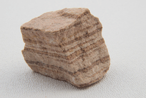
    Sandstone forms from beach sand-sized quartz grains that are glued together with quartz or calcite or compressed until they harden into a rock.

  • Glad You Asked—Where can I collect landscaping rock on public land?

    Updated: 2011-02-03 23:02:55
    Decorative stone public collecting localities Landscaping rock can be collected from “community pits” on U.S. Forest Service and Bureau of Land Management (BLM) public lands. Common-use areas/community pits are for noncommercial or small-scale collection and require a permit. The rules and stipulations for collecting vary from region to region and pit to pit. For details on obtaining [...]

  • GeoSights—Fremont Indian State Park, Sevier County, Utah

    Updated: 2011-02-03 22:56:29
    Fremont Indian State Park is named after a diverse group of people, the Fremont Indians, who lived in Utah from A.D. 400 to 1350. The park exists because of successful archaeological excavations in Clear Creek Canyon prior to construction of Interstate 70 between Richfield and Cove Fort, Utah. There are at least 10 Fremont sites [...]

Current Feed Items | Previous Months Items

Jan 2011 | Dec 2010 | Nov 2010 | Oct 2010 | Sep 2010 | Aug 2010